LEO, MEO, GEO: A Plain-English Guide to the Major Orbital Regimes
Different jobs need different orbits. From Starlink at 540 km to GPS at 20,000 km to TV satellites at 35,786 km — what each regime does best.
Three altitude regimes dominate satellite operations. Each has different latency, coverage, lifetime, and cost characteristics — and the right altitude is the single biggest design decision for any mission.
Low Earth Orbit (LEO): 200 - 2,000 km
LEO has the shortest latency (~5 ms one-way for direct line of sight), the lightest cost to reach, and the highest resolution for imaging. The downside is limited coverage area per satellite — you need a constellation. ISS, Hubble, Starlink, OneWeb, Earth-observation satellites, and most CubeSats live here.
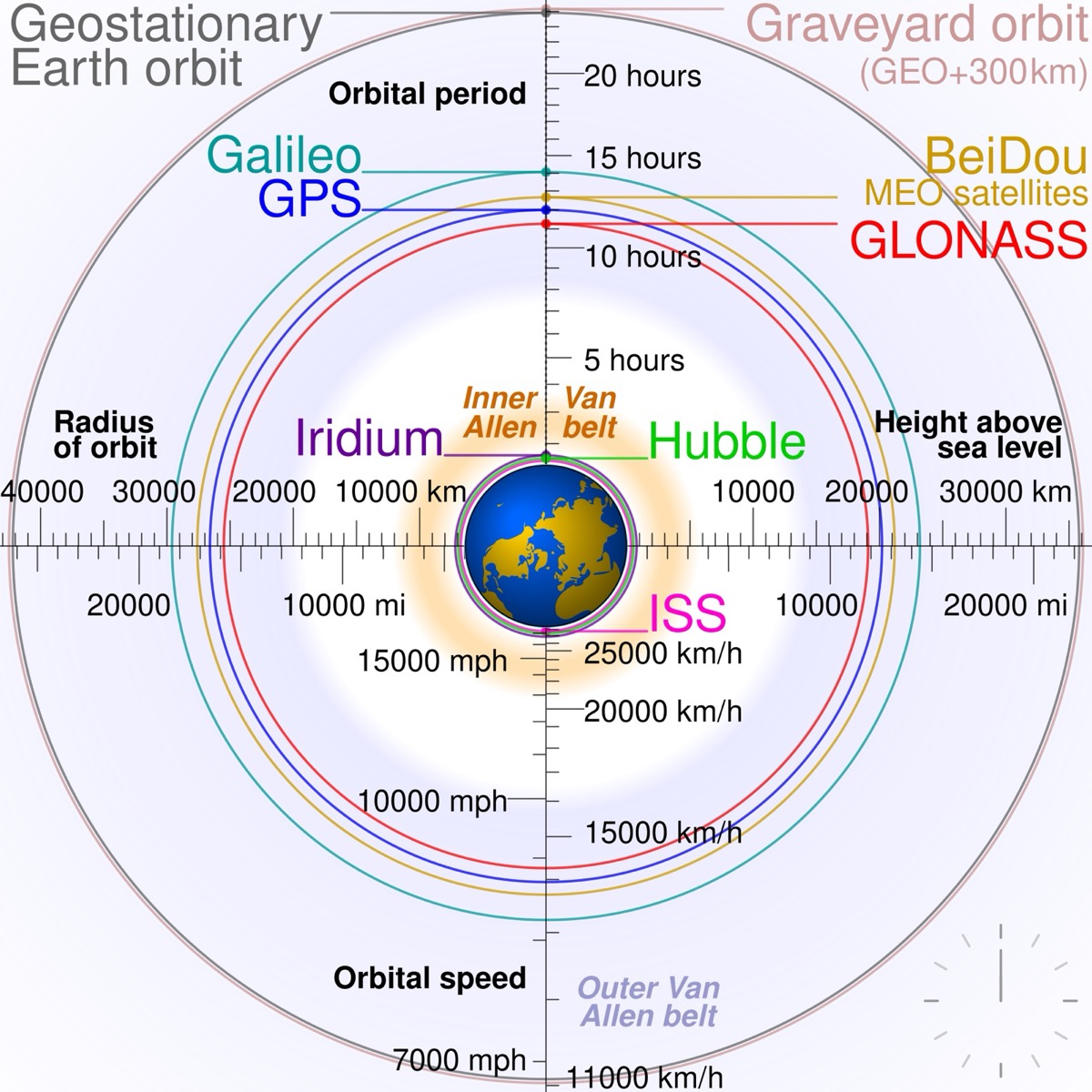
Medium Earth Orbit (MEO): 2,000 - 35,786 km
MEO is the home of navigation satellites. GPS at 20,200 km, Galileo at 23,200 km, GLONASS at 19,100 km, BeiDou at 21,500 km. Twelve to twenty-four satellites give continuous global coverage. Latency is moderate, lifetime is decades.
Geostationary Orbit (GEO): 35,786 km
A satellite at GEO orbits Earth in exactly 24 hours, in the equatorial plane, so it appears stationary in the sky. Three GEO satellites can cover the entire planet (excluding far poles). TV broadcast, weather satellites, and traditional communications live here. Latency is high — about 250 ms one way.
- LEO altitude
- 200-2,000 km
- MEO altitude
- 2,000-35,786 km
- GEO altitude
- 35,786 km (exact)
- HEO (highly elliptical)
- Spans LEO to GEO and beyond
- LEO orbital period
- ~90 minutes
- MEO orbital period
- ~12 hours (typical)
- GEO orbital period
- 24 hours
Specialty orbits worth knowing
- Sun-synchronous (SSO) — a polar LEO that crosses the equator at the same local time every day, ideal for imaging.
- Molniya — highly elliptical, 12-hour period, used for high-latitude communications.
- Tundra — a 24-hour highly elliptical orbit for high-latitude broadcast.
- Lagrange L1, L2, L4, L5 — gravitational equilibrium points for deep-space observatories like JWST.
How operators choose
Latency-sensitive applications (video calls, gaming, real-time control) want LEO. Continuous coverage with a small fleet wants GEO. Global navigation needs MEO. Long-duration deep-space science wants Lagrange points. Constellation operators trade satellite count vs altitude until cost-per-coverage is minimized.
Frequently asked questions
What altitude is "the Karman line"?
100 km — the internationally recognized boundary between Earth's atmosphere and space. Suborbital flights cross it but do not reach orbital velocity.
Can a satellite be in two regimes at once?
Highly elliptical orbits dip into LEO at perigee and reach near-GEO at apogee, technically passing through multiple regimes per orbit.
Why is GEO crowded?
GEO is a single thin ring 35,786 km up. Slots are limited, allocated by ITU, and increasingly contested by operators worldwide.
Get every launch in your pocket.
Real-time alerts, live ISS tracking, AR sky mode, and synchronized T-0 haptic across every device worldwide.
Download on the App Store